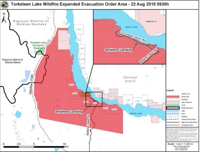
The Regional District of Bulkley-Nechako (RDBN) has expaded the evacuation order for the Torkelsen Lake Fire, which has burned 1,300 hectares approximately 20 km south of Fort Babine.
The expanded evacuation order is in effect for the area east of the Nilkitkwa Forest Service Road (FSR) along the shore of Babine Lake, north of TSAK 9 (not including TSAK 9), south of Smithers Landing and east of L3752.
Fire officials concerned
Fire officials are concerned about the safety risk to those individuals refusing to abide by the evacuation orders for the Nadina and Verdun fires given the weather forecast for the next 72 hours. Fire growth is anticipated as well as extreme fire behaviour.
READ MORE: Some residents south of Burns Lake refuse to evacuate
The Nadina Lake Fire, located approximately 60 km southwest of Burns Lake, has burned 78,331 hectares.
The Verdun Mountain Fire, located approximately 10 km southwest of Grassy Plains, has burned 17,326 hectares.
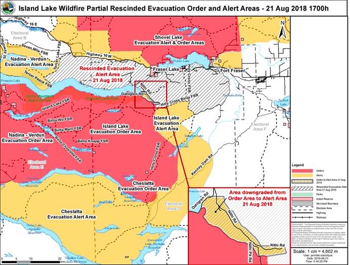
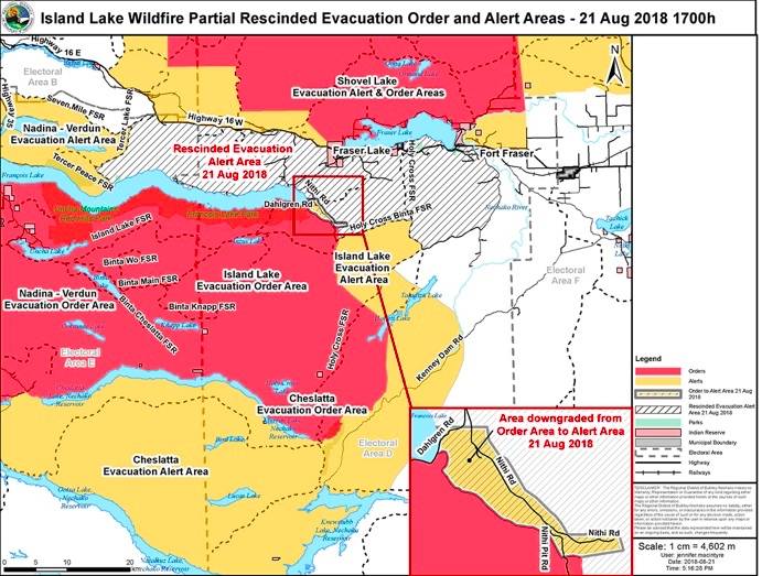
Evacuation order for Island Lake Fire partially rescinded
A portion of the evacuation order and evacuation alert issued Aug. 8 and Aug. 13 respectively for the Island Lake Fire, which is burning south of Francois Lake, has been rescinded.
An evacuation order remains in effect for the Binta Wo FSR to a portion of Holy Cross Binta FSR; south of Francois Lake to above the Binta Main FSR including Francois Lake Provincial Park. Including two islands located on the east end of Francois Lake, Lots 2714 and 2713.
An evacuation alert remains in effect for south of the Holy Cross Binta FSR and east of the Holy Cross FSR including a small northern portion of Dahlgren Road and Nithi Road; south to and including 11777 Nithi Pit Rd.
Portion of evacuation order for Shovel Lake Fire rescinded
The RDBN has also rescinded a portion of the evacuation order issued for the Shovel Lake Fire.
An evacuation order remains in effect for east of the center of Taltapin Lake and the Bomberger FSR to south of the Camsell FSR-Cunningham FSR Junction and Cunningham FSR-Marie North FSR Junction; the west and north shore of Fraser Lake to Dog Creek Rd. and Nadleh River.
An evacuation alert remains in effect forthe Dog Creek Community west and east of Hwy. 27 along Cook Road and Kenner Road; the Echo Lake Bible Camp; east of the Augier Main FSR to east of Hwy. 27; North of Hwy. 16 and approximately 14 km north of the Hwy. 16 and Hwy. 27 junction to Stuart Lake.
@flavio_nienow
flavionienow@gmail.com
Like us on Facebook and follow us on Twitter.