Fire officials are concerned about the inherent safety risk to those individuals refusing to abide by the evacuation orders for the Nadina and Verdun fires on the Southside given the weather forecast for the next 72 hours.
The Nadina Lake Fire is now estimated at 78,002 hectares while the Verdun Mountain has consumed 16,978 hectares.
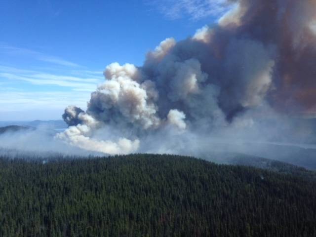
Fire growth is anticipated this week as well as extreme fire behaviour.
“Being placed on an evacuation order or engaging in fire suppression operations independently, can be a difficult and emotional experience; however, choosing to remain in an area under evacuation order puts yourself, your family, and potentially first responders in danger,” said the B.C. Wildfire Service in a statement today.
“If you have chosen to remain in your home in the event of an evacuation order, it is important to understand that we may not be able to assist you, as you have been advised to leave the area for your own safety and we need to ensure the health and safety of our firefighters as well.”
“The protection of first responders and the public is the number one priority for B.C. Wildfire Service, which includes ensuring the safety of our own personnel.”
According to the B.C. Wildfire Service, remaining in an area under an evacuation order can also impede their ability to fight the fire, as they may be forced to stop certain suppression activity to not put people who have stayed behind in further danger.
Shovel Lake Fire, 86,397 hectares (estimated)
According to the B.C. Wildfire Service, the Shovel Lake Fire has not moved towards Hwy. 27, Fort St. James, or Hwy. 16 in the past five days.
It is currently 14.5 km from the furthest eastern point of the fire to Hwy. 27; however, the main eastern flank of the fire is still between 20 km-23 km away from Hwy. 27. The fire is still also holding north of the PNG pipeline guard on the southern flank.
Thick smoke continues to challenge the use of aircraft – including helicopters, airtankers, and water skimmers – due to visibility concerns.
Beginning today through Thursday afternoon, wind gusts will pick up with prevailing 15 km/hr from the southwest with possible gusts up to 30 km/hr. The B.C. Wildfire Service says crews will work to address any increases in fire behaviour.
The Trout Lake FSR is closed due to fire activity. The Sutherland Road is closed from the 15 km mark.
Evacuation Order is in effect.
READ MORE: Shovel Lake Fire update as of August 21, 2018 – 11:00 am
Island Lake Fire, 17,291 hectares (estimated)
The Island Lake fire remains active, but visibility is very poor over the fire.
According to the B.C. Wildfire Service, the smoke is reducing fire behaviour; however, it is difficult to determine the exact location of the fire perimeter. Air support has been grounded for the most part of the last two days.
Structural firefighters are monitoring for values in need of structural protection in the area and on the lakeshore.
Evacuation order is in effect.
Torkelsen Lake Fire, 1,300 hectares (estimated)
This fire continues to burn near power lines in the area, but is not an issue at this time, according to the B.C. Wildfire Service. The fire is currently about half a kilometer from the nearest structure.
Evacuation alert is in effect.
Gilmore Lake Fire, 216 hectares (estimated)
This fire remains 100 per cent contained and within the perimeter. There was one spot fire yesterday that crews were able to deal with quickly. Crews will continue to mop up spots along the south flank and the southeast corner and continue to contain any fire that has slopped over the perimeter.
Evacuation alert is in effect.
For a complete list of evacuation orders and alerts, visit https://www.rdbn.bc.ca.
@flavio_nienow
flavionienow@gmail.com
Like us on Facebook and follow us on Twitter.