As the snow begins to melt, official assessments of the winter snowpack reveals a mixed bag of results for northern British Columbia.
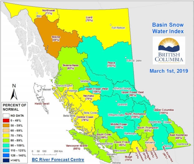
For the Upper Fraser West basin, which includes Burns Lake, Fort St. James and Vanderhoof, the snowpack is at 106 per cent of the normal level, according to the March 1 data of the BC River Forecast Centre.
However, the Nechako basin - in areas including Tahtsa Lake, Skins Lake and Mount Pondosy - is at 79 per cent of the normal snowpack level.
The Skeena-Nass basin - northwest of Burns Lake and comprising Houston, Smithers and Terrace - is at 82 per cent of the normal level.
For the approaching spring melt, the snowpack level around Burns Lake entails “close to normal runoff for volume and peak flow,” Dave Campbell, head of BC River Forecast Centre told Black Press.
The wider implications of those levels, such as possible drier ground and greater risk of wildfires were too early to assess.
“How does the weather pan out after the [spring] melt? That becomes the key determinant. The northwest has seen a lot less precipitation this winter and spring. Once this snow melts we’ll switch into those dry conditions…If this dry persists it doubles up on those impacts,” Campbell explained.
“The piece that’s uncertain is how much rain we’ll get. That can add a fair bit to the runoff.”
Environment Canada forecasts show that precipitation levels for much of northern B.C. are about 40 per cent below normal for March-April-May, and temperatures around the same probability for most of the province for the same period.
Campbell stressed that the April 8 survey should give a clearer picture of the implications of the snowpack, as that sample takes in the peak accumulation of the snow.
The snowpack for March of 2019 is lower than for last March when it was 138 per cent above normal.
By April of last year it went higher, leading to floods in the Burns Lake area when the snow melted.
LOOK BACK: UPDATED: Roads disrupted around Burns Lake as flood warning issued in region
Two years ago it was significantly lower, at 66 per cent in March and 85 per cent in April.
READ MORE: Below-normal snowpack in the Lakes District
Blair McBride
Multimedia reporter
Send Blair an email
Like Lakes District News on Facebook