Houston Search and Rescue is heading an advancement which will have nation-wide impact.
The way Houston is applying mapping technology to Search and Rescue (SAR) is drawing both provincial and national interest, said Chris Mushumanski, Director of the B.C. Search and Rescue Association.
"The impact could be pretty significant in the SAR world.
"This is the biggest technological advance I've seen in 17 years. It's greater then when the very first handheld GPS came out, and that was pretty significant. This is well beyond that because it does what a GPS does plus ten times more," he said.
Paper maps are the main tool used by SAR teams across the province, with GPS being used among teams who could afford it, Mushumanski said.
But Houston is leading a major shift.
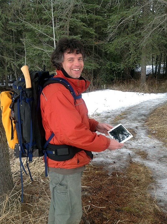
It all started a year ago with Andy Muma, Houston Search and Rescue SAR director.
Houston SAR was gearing up to buy several new $450 GPS devices when Muma suggested they try a few $550 iPads instead.
Muma works for the B.C. Government researching technology to match it with government field work.
Seeing the difference it makes in government field work, Muma said he thought the device would be perfect for SAR.
Houston SAR bought four iPads and Muma downloaded and tailored several apps, including a mapping app, to suit SAR needs.
The Houston crew has used iPads in three searches since buying them in February 2013. Muma says it made a huge difference.
When a local trapper got stranded on Morice Lake last November, a Houston SAR team made a successful night-time rescue, navigating the massive lake in a boat through the pitch black night to save the trapper.
"Without the iPad, they wouldn't have been able to go out at night. They would have stayed and waited until morning," Muma said.
Improved navigation is just the beginning of the changes that come with iPads.
Before the iPad, searches were done using paper maps and GPS. Muma explained the search organizing process:
RCMP would get a call that someone was missing. They would contact SAR and meet with a search manager.
Muma says RCMP often wouldn't have a map, but would explain to the manager the general area where the person was last seen. The manager would then contact someone in forestry or government to start printing maps - not knowing the exact area but producing maps of the general area to be ready for searchers.
Then the maps would be rushed to the manager who would then manually sketch out search areas on the maps. He would meet with the searchers, often 25 people, and distribute the maps.
If more accurate information was received and the area changed, it would be back to the computer to print new maps.
Then the search would begin.
In contrast, the iPad takes what is often a six-hour process and shortens it to minutes.
When the RCMP get a call about a missing person, they meet with the search manager and give the point the person was last seen. The manager would document the information on the iPad app, including a description of the person and a photo if available. They would lay out search areas and label them for search leaders, and then email everything to their 25 searchers.
Searchers would load the information from the email directly into their iPad map and the search would begin.
"It's hours the old way, and literally minutes with the iPad," Muma said.
When searchers scour a search area, they use the iPads to navigate and document clues accurately. It avoids overlap and mistaken documentation, which is easy when working only with paper maps and GPS, said Muma.
The iPad also brings accuracy and speed to the compiling process which follows a search.
In the past, searchers would gather with maps, scribbles in notebooks and pictures on cameras.
The search manager would manually collect the data from all 25 searchers, making sure photos are matched with the location they were found.
"That's where mistakes happen," Muma said.
With the iPads, Muma says they can simply transfer data between iPads using airdrop, which is instant and allows perfect accuracy.
Muma said the iPad is also great because it's user-friendly, easy to train searchers on, and its compatible with iPhones and smartphones.
It's also replaces six different field tools - maps, notebooks, camera, video recorder, GPS and communication platform.
"It takes six jobs and puts it in one device," Mushumanski said.
Mushumanski says it will also make a big difference when teams in the region work together.
After the technology was discovered, SAR applied for regional funding to get iPads for all the SAR groups in the region.
The Regional District of Bulkley-Nechako funded $29,576 to the SAR groups across the region to buy iPads.
Muma is heading up a regional iPad training meeting on March 29. They are expecting 40 searchers from Vanderhoof, Smithers, Fort St. James, McKenzie and Prince George.
In early May, Muma will present in Prince George to 24 SAR teams from northern B.C. about the iPad.
"It's a game changer," Muma said.