The Gilmore Lake Fire, located eight km southwest of Topley, was estimated at approximately 200 hectares and 100 percent contained Monday. The RDBN has implemented an evacuation order and alert for this wildfire. It has burned approximately 200 hectares since it was discovered Aug. 7. The fire, which was caused by lightening.
According to the B.C. Wildfire Service, the fire saw “extremely vigorous” activity last Thursday that challenged containment efforts.
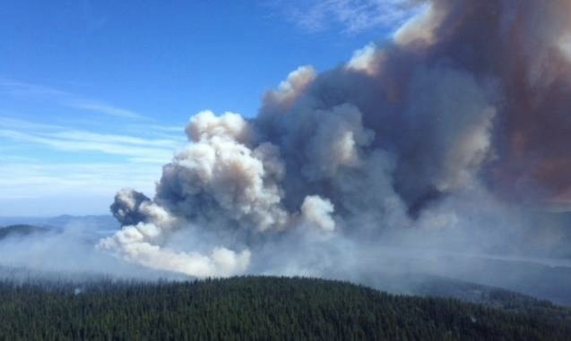
Air tankers supported crews with bucketing efforts in order to help protect nearby structures, critical infrastructure and the Hwy. 16 corridor. Sprinkler protection units had also been mobilized on nearby structures.
A total of 21 firefighters and 16 helicopters were at the site last week. In addition, 37 support personnel and 16 helicopters are shared amongst all fires comprising the region.
Shovel Lake: Over the weekend the Regional District of Bulkley-Nechako (RDBN) expanded the evacuation order and evacuation alert for the Shovel Lake Fire, which is burning approximately 30 km northeast of Burns Lake.
As of Monday, the expanded evacuation order was in effect for the area east of the center of Taltapin Lake to west of the Sutherland Forest Service Road (FSR) and Trout FSR; south of the Camsell FSR-Cunningham FSR Junction and Cunningham FSR-Marie North FSR Junction to approximately three km south of Tatin Lake.
The expanded evacuation alert is for the area east of the Augier Main FSR to Necoslie and Dog Creek FSR; north of Hwy. 16 and the north shore of Fraser Lake; south of Stuart Lake and Mount Pope Park.
As of Monday, the B.C. Wildfire Service was recommending an expansion of the evacuation alert area to include the community of Fort St. James.
The Shovel Lake Fire has consumed 30,000 hectares after experiencing significant growth last week. This fire moved north and is now between Justine Lake and the Trout Forest Service Road. The fire is approximately 6.7 km north of Endako and Hwy. 16.
Verdun Fire: Over the weekend the RDBN also expanded the evacuation order and evacuation alert for the Verndun Mountain Fire, which is located 17 km southwest of Grassy Plains. This fire has burned approximately 4,500 hectares.
The expanded evacuation order is in effect from the Tatalaska FSR south to Ootsa Lake; Keefes Landing Road east to the end of Takysie Lake, Cheslatta Road and Square Lake.
The expanded evacuation alert now includes Tatalrose Road south to Ootsa Lake, west of Tatalrose Lake to Ootsanee Lake and Uncha Lake.
The Francois Lake Forester Ferry has been operating extended hours as required to support the needs of the evacuation order.
The check out the full list of evacuation orders and alerts, visit https://www.rdbn.bc.ca.
Wildfires showing “aggressive behaviour”
Other wildfires in the Burns Lake region continued to grow last week, with some showing “aggressive behaviour,” according to the B.C. Wildfire Service.
The Nadina Lake Fire, burning 63 km southwest of Burns Lake, was estimated at 25,000 hectares on Monday.
Last week this fire displayed aggressive behaviour and grew rapidly. The fire took a considerable northeasterly run and is approximately 10 km west of the western end of Francois Lake.
The RDBN expanded the evacuation order and alert for this wildfire last week.
The Island Lake Fire, located south of Francois Lake, was estimated at 11,300 hectares on Monday.
Although the fire did not show any additional growth in the past few days, it continued to hold in the marsh area in the east, east of the Nithi Pit Road.
The RDBN has also implemented an evacuation order and alert for this wildfire.
The Torkelsen Lake, located approximately 24 km south of Fort Babine, has consumed 850 hectares and remained zero per cent contained Monday. No structures had been affected. Ground crews, rotary-wing aircraft, and heavy equipment were continuing to work to protect identified values in the area.
The RDBN has recently revised an evacuation order for this fire.
The RDBN has also issued an evacuation alert and evacuation order for the Tweedsmuir Complex fires, and an evacuation alert for the W Babine River Fire.
For the most up-to-date list of evacuation orders and alerts, visit http://www.rdbn.bc.ca/.
www.twitter.com