The 2017 B.C. wildfire season, now considered the worst on record, is not near the end just yet.
According to the Northwest Fire Service, the current campfire ban is expected to remain in place until noon, Friday, Oct. 20, 2017 or until the public is otherwise notified.
Olivia Pojar, information officer for the Northwest Fire Centre, explained that August and September are generally active months in terms of wildfire activity in B.C. This is due to the fact that forest fuels have had a few months of warm weather to dry out. In addition, the prevalence of lightning often increases later in the summer.
According to Environment Canada, the Houston area is expected to see above normal temperatures in August, September and October.
The fire danger rating was “high” to “extreme” throughout the Northwest Fire Centre last week. Pojar explained that significant precipitation would be necessary to reduce the rating.
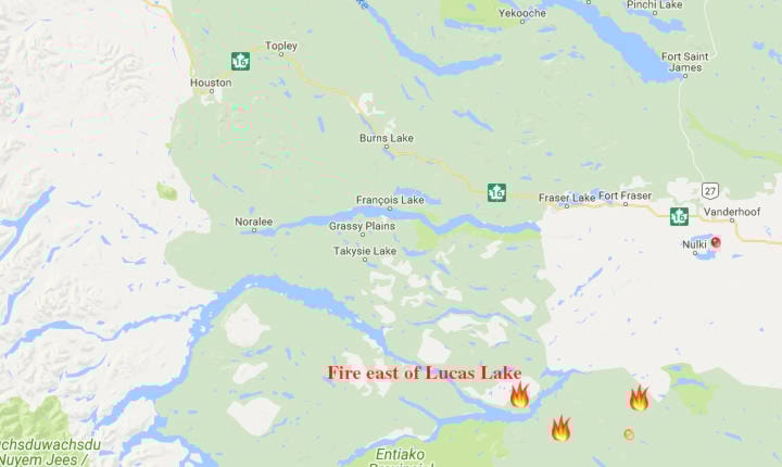
As of last week, the closest wildfire to Houston was burning east of Lucas Lake, about 92 km southeast of Burns Lake. This wildfire has been burning since July 8 and has consumed over 8300 hectares.
Although this fire has seemingly grown in size compared to what was being reported earlier this month, Pojar said there has not been a significant growth in the past few weeks.
“The larger size is due to more accurate mapping that was not possible before due to smoky conditions,” she said.
The status of this fire is “being held,” which indicates that the fire is not likely to spread given the current and forecasted conditions and the resources currently committed to the fire. A total of 47 firefighters, one helicopter and four heavy equipment have been deployed to the area. No communities or structures are currently threatened.
An order of restricted access is in place for areas around this wildfire. While the order is in effect, no one is allowed to remain in or enter the designated areas described below:
- All roads accessed by the Kluskus Lavoie Forest Service Road (Gold Road) beyond the 13-km mark;
- All roads accessed by the Kluskus Forest Service Road beyond the 77-km mark;
- All roads accessed by the Kluskus 500 Road beyond the 28-km mark (the 528 sign) just west of Kenney Dam.
The B.C. Wildfire Service reminds the public that all types of open burning, including campfires, are prohibited throughout the Northwest Fire Centre.